


A dual strategy of ecological restoration and smart forecasting for a flood-resilient Bangladesh
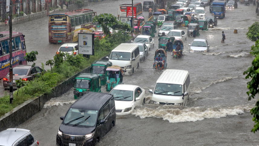
Flooding is inseparable from Bangladesh’s identity. For centuries, the country has been shaped by rivers as monsoon water spread across floodplains, replenished wetlands, and drained through a vast network of rivers, canals, beels, and haors. However, while floods are natural, the growing destruction they cause is not. Climate variability is making floods harder to anticipate, but climate alone cannot explain why water increasingly becomes trapped around homes, roads, and farmland. Over the years, people have occupied floodplains, filled wetlands, blocked canals, and built roads and embankments across natural flow paths. We are steadily removing the places where floodwater once went.
Research by the University of Texas at Arlington found that nearly 600,000 square kilometres of natural floodplains were converted to agricultural and urban land worldwide between 1992 and 2019—an area about four times the size of Bangladesh. When a floodplain is filled or disconnected from a river through unplanned development, its storage capacity does not disappear without consequences: water rises higher upstream, moves faster through narrow openings, remains trapped longer, or is redirected towards communities that were previously less exposed.

The country now needs a two-part strategy: i) protect and restore its floodplains, canal networks, and native haor wetlands; and ii) build a new generation of impact-based early warning system using AI, hydrological models, and local observations blended with the latest satellite data. One cannot succeed without the other.
Major cities in Bangladesh are already showing what happens when natural water storage areas and drainage pathways are lost. In Dhaka and Chattogram, the filling of low-lying land, wetlands, ponds, and canals has left stormwater with fewer places to go. As a result, even moderate rainfall can overwhelm drainage systems, and streets turn into waterways, homes become islands, and floodwater takes much longer to recede.
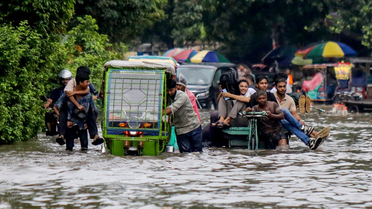
The same pattern is increasingly threatening the haors of Sylhet and Sunamganj. Haors are among the country’s most important natural flood management systems. During the dry season, haors support rice production, fisheries, and livestock grazing. During the monsoon, these depressions receive rainwater and become vast, interconnected water bodies. Destroying or fragmenting them is not merely an environmental loss but is equivalent to dismantling part of the country’s flood control infrastructure. Roads built across these haors can divide a connected wetland system into artificially wetter and drier sections. Farmers and environmentalists have warned how haor roads and the development that follows could invite disasters. The repeated flooding in the aftermath of these developments reinforced such concerns.
That Bangladesh needs roads and reliable transportation for haor communities is beyond question. But such infrastructure must be designed around the pathway of the water rather than imposed across it. Roads should include adequately sized and properly located bridges, culverts, causeways, and overflow sections that preserve natural water movement. Selective elevated sections could also work without turning the entire roadway into a barrier. However, once natural drainage and water storage areas are lost, engineered solutions become increasingly costly and less effective.
Using AI and satellite data for precision forecasting
While Bangladesh has made significant progress in flood and cyclone preparedness, the current operational capacity focuses mainly on forecasting river levels at selected locations. The hydrological information system is underdeveloped too: when localised cloudbursts and extreme rainfall coincide with transboundary runoff, they generate catastrophic inundation within hours. Conventional forecasting, constrained by delayed data, limited upstream monitoring, and slow computer processing, cannot capture such sudden, highly localised anomalies in advance. At the community level, effective disaster risk reduction requires more precise information, such as which villages will be inundated, which roads will become impassable, how deep the water will be, when a flash flood will reach a particular haor, and how long the flooding will last. A next-generation flood mapping system must move beyond predicting river water level to answer these questions.
This is where AI can help by deriving “smart” location-specific flood forecasts. AI models can learn from rainfall, river levels, land elevations, land use, previous floods, and infrastructure conditions. They can identify flood patterns that are difficult to capture using a limited number of river gauges, particularly in ungauged and sparsely monitored areas. However, Bangladesh cannot simply import a model trained somewhere else. The system must be built and tested using Bangladeshi data, aided by advanced scientific expertise and community knowledge.
Similarly, the latest satellites offer capabilities that were unimaginable even a decade ago. Nasa’s Global Precipitation Measurement Mission provides near real-time rainfall estimates over Bangladesh and upstream transboundary basins. European Sentinel-1 satellites use radar to observe the Earth through clouds, rain and darkness, making them especially valuable during monsoon floods. The Nasa-French Surface Water and Ocean Topography (SWOT) mission can measure changes in the width and elevation of rivers, lakes and wetlands. When combined with river gauges, weather forecasts, and community observations, these satellites could power an AI-enabled system that updates continuously. The result could be dynamic maps showing expected flood arrival time, water depth, duration, road accessibility, and potential impacts on crops and homes. Warnings could be delivered through mobile phones, local government offices, schools, community volunteers, and agricultural extension networks.
This technology should not be reserved for emergencies. AI and satellite data can also reveal where development is creating future disasters. Satellite observations can identify where a haor has been fragmented, a canal has narrowed, or construction has expanded into a flood storage area. AI can test thousands of rainfall and infrastructure scenarios to identify where flow restrictions could cause dangerous waterlogging. Before approving a road, housing development or industrial project in a floodplain, the authorities should be required to answer one basic question: where will the displaced water go?
Bangladesh also needs an integrated national water data platform where government agencies, universities and local organisations can work from consistent, regularly updated information. Even the most advanced warning system will fail if rainfall, river, wetland, infrastructure and land use data remain scattered across agencies or inaccessible. Publicly funded environmental data should be documented, interoperable and accessible to those responsible for protecting communities, agriculture and infrastructure.
However, no technology can replace a filled haor, reopen a blocked canal, or restore a floodplain buried beneath concrete. A smart flood mapping system may tell a community that it will flood tomorrow, while protecting wetlands and restoring drainage can reduce that risk for decades. The country must stop treating haor conservation, floodplain protection, infrastructure planning, and flood forecasting as separate issues. They are dimensions of the same national water security challenge, and they must be governed together. The real question is whether the institutions that approve our roads, bridges, and embankments understand this connection. Adopting a unified strategy pairing precision forecasting with ecological restoration is essential to make Bangladesh flood-resilient.
Dr Adnan Rajib is assistant professor of civil engineering and director of h2i Lab at the University of Texas at Arlington in the US.
Dr Tanvir Manzur is professor and director of the BUET-Japan Institute of Disaster Prevention and Urban Safety at Bangladesh University of Engineering and Technology.
Dr Mir Matin is manager of the Geospatial, Climate and Infrastructure Analytics Programme at the United Nations University Institute for Water, Environment and Health (UNU-INWEH) in Canada.
Dr Md. Sabbir Mostafa Khan is professor and head of the Department of Water Resources Engineering at Bangladesh University of Engineering and Technology.
Views expressed in this article are the author's own.
Follow The Daily Star Opinion on Facebook for the latest opinions, commentaries, and analyses by experts and professionals. To contribute your article or letter to The Daily Star Opinion, see our guidelines for submission.
 For all latest news, follow The Daily Star's Google News channel.
Comments