


What dying mangroves tell us about coastal governance in Bangladesh

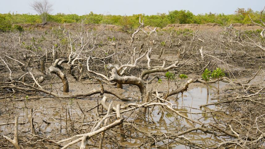
Recent reports on mangrove clearing in Sonadia Island for shrimp farming, salt production, and human settlement reveal that mangroves are early warning indicators of governance performance along Bangladesh’s coastal frontier, and right now, those warnings are flashing red.
Mangroves are among Bangladesh’s most important natural defences along its coastlines. The Sundarbans represent only part of the country’s mangrove landscape. Its mangrove inventory also includes extensive coastal mangrove plantations along the central coast, the historic mangroves of Sitakunda and Chakaria, naturally regenerated mangroves in Teknaf and Sonadia Island, and numerous smaller mangrove patches along rivers and tributaries in the southwest, particularly in Khulna, Satkhira and Bagerhat districts.

Because of their wide geographic and functional reach, mangroves are integral to coastal protection and land use governance in Bangladesh, particularly along its coastal frontiers. Their ongoing losses are thus not simply environmental concerns but also governance issues. This governance dimension becomes clearer when we examine the history of mangrove change in the country, particularly in areas where mangroves have already been lost.
The Chakaria Sundarban in Cox’s Bazar, not far from Sonadia, is an ideal example. Once considered the country’s second-largest mangrove ecosystem and one of the oldest in South Asia, Chakaria Sundarban has disappeared entirely from the country’s map, transformed over the decades into shrimp farms, salt ponds, and other land uses. Chakaria showed that mangroves rarely disappear overnight; they are destroyed through a sequence of administrative and policy decisions that gradually weaken ecological protections, leaving little to conserve or restore.
Unfortunately, what happened to Chakaria Sundarban is now happening to Sonadia. Newly established mangrove areas are now being cleared for aquaculture and salt production, with repeated reports of encroachment and weak enforcement of ecological protections. From aerial perspectives reflected in media imagery, the continuous green canopy seems to give way to grids of ponds, water bodies, and exposed land. This is not simply degradation; it is ecosystem replacement—a deeply unsettling fact. Yet, the institutional response remains largely invisible. Sonadia is demonstrating, right before our eyes, how quickly protection can collapse when the economic value of converted land outweighs the perceived value of mangrove ecosystems.
Across Bangladesh’s other coastal regions, mangrove plantations and buffer zones continue to expand on paper, while decisions over land allocation and reclassification, particularly on newly accreted lands where mangroves are raised, are often made by district administrations and other government authorities, except where areas are formally designated as reserve forests. In practice, ecological protection frequently competes with administrative priorities related to settlement expansion, agriculture, aquaculture and coastal development. This often results in a shifting forest boundary: mangroves are restored in one location (for example, on newly accreted coastal lands) while being converted elsewhere (including older coastal plantations, small, fragmented patches in the southwest, Chakaria, Sonadia, and others).
Across these coastal landscapes, a consistent pattern appears. Mangroves tend to decline in areas where land becomes politically and economically convertible. In most cases, if not all, the primary drivers are not small-scale users struggling for subsistence. Land conversion is often enabled by political or other forms of influence, weak coordination among government agencies, and administrative decisions made with limited regard for ecological consequences.
That said, Bangladesh has invested substantially in mangrove plantation programmes, and recent government plans for large-scale planting across the country, including coastal areas, are a positive move. However, such efforts alone cannot compensate for ongoing mangrove clearing. Additionally, a planted mangrove cannot survive where land has already been irreversibly converted, nor can restoration planting succeed if governance changes faster than ecosystems can recover.
In this context, the central challenge of mangrove conservation is not a lack of scientific knowledge or technical capacity. The constraint is institutional. In many coastal areas, district administrations retain significant authority over land allocation and reclassification, which can undermine mangrove protection. At the same time, the Forest Department has limited influence over broader land use decisions. As a result, mangrove forests may be formally protected but remain institutionally insecure. This is mainly because responsibility for land, forests, and coastal development is dispersed across multiple government agencies, while their accountability remains poorly aligned and weakly coordinated. This creates a persistent gap between what is known, what is decided, and what is enforced. It is precisely the space in which mangroves gradually disappear. Bangladesh does not lack understanding of its mangrove systems or their value; it lacks alignment in how decisions are made and implemented.
Shekhar R Biswas is professor of ecology at East China Normal University in Shanghai.
Views expressed in this article are the author's own.
Follow The Daily Star Opinion on Facebook for the latest opinions, commentaries, and analyses by experts and professionals. To contribute your article or letter to The Daily Star Opinion, see our guidelines for submission.
 For all latest news, follow The Daily Star's Google News channel.
Comments